VHF_Ground to air (G2A)_coverage
Our Services

Advanced Radio network planning and modelling

Supporting every stage of the radio network lifecycle

ATDI supports civil aviation authorities, air traffic controllers, national regulators and airport authorities to manage their wireless connectivity. With growing pressure on the use of wireless technologies, ATDI delivers reliable, cost-effective software solutions and services to enable organisations to handle their radio spectrum efficiently.

Our software solutions and services cover the full scope of airport and airspace comms from air-to-ground (A2G), ground-to-ground (G2G) and air-to-ground (A2G) for network planning and optimisation, and analyses communications, navigation and surveillance (CNS) radio instruments.

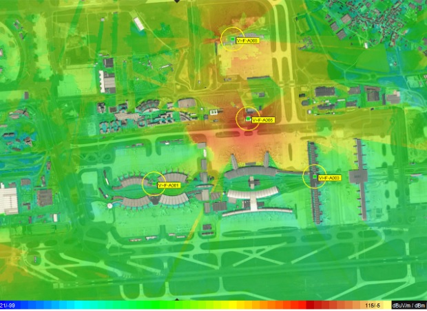
Our flagship software solution, HTZ supports the full range of aviation communication systems including aeronautical comms (HF, VHF/UHF, MW, Satellite and HAPS), navigation systems (ILS, VOR, DMS, DME-DME), surveillance (radars) and multilateration (sensors). HTZ designs smart airports by supporting IOT technologies like LoRa, SigFox, and WiFi and provides spectrum coordination at national and regional levels.

Our dedicated engineering and software development teams ensure that our solutions continue to grow and evolve. Our technology-neutral solutions manage any radio technology across the spectrum, allowing users to model multiple radio technologies across one project.


ILS coordination

ILS  coordination area

A2G LTE coverage - DL SNIR

Air-to-ground (A2G) LTE coverage shows the DL and SNIR outputs

VOR intrusion

Intrusion of aircraft into VOR coverage

Modelling aircraft transmitters
Modelling coverage from aircraft transmitters
Footprint depiction_Airside
Coverage footprint (airside) for 
Coverage Prediction_Airside-1
Coverage prediction (airside) for TETRA

Use Cases & Product Features


5G coverage map in 3D
Case Study

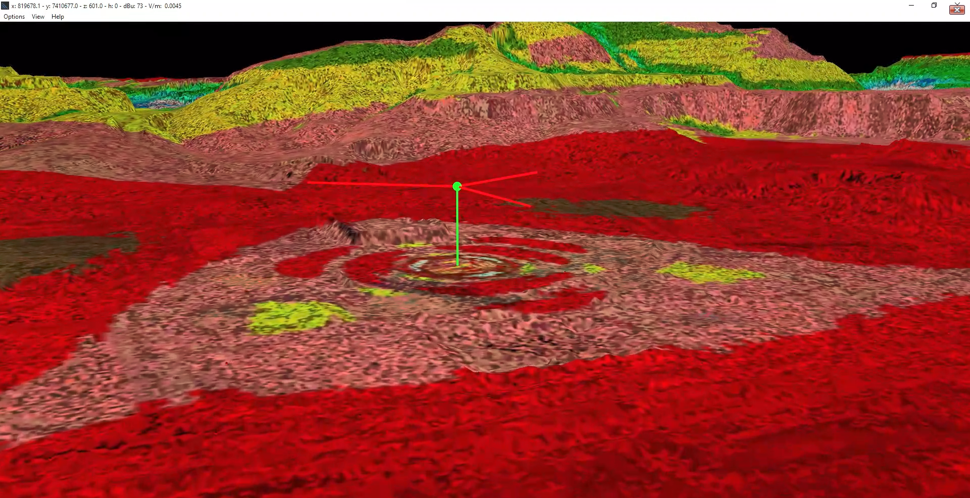
Protecting military radars from 5G interference

Protecting vital resources like the C-band air defence systems for target detection, recognition and weapon control is essential to national security. ATDI completed a nationwide study on radio propagation, interference analysis and mitigation techniques for 5G towers close to aeronautical radars. 


Full article

Radar areas covered with existing and new buildings at 800 ft
Case Study

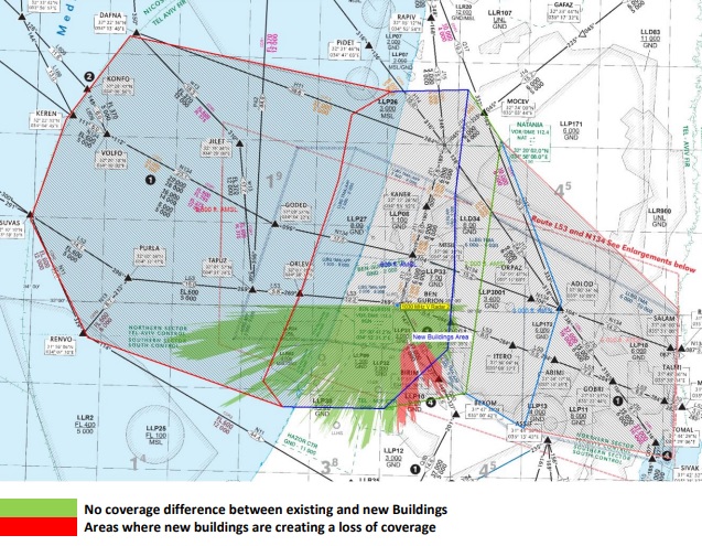
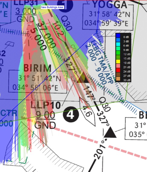
Modelling impact of new buildings on VHF coverage

Using HTZ, ATDI simulated the impact of a new building on the airfield. The new building footprint was overlaid on the map and the Deygout 94 propagation model was applied. Simulations were calculated at 1m for ground use and 3m for aircraft receiver heights. The study provided coverage plots for receive and transmit sites with a field strength below ICAO recommendations. 


Full article


Coverage analysis for ILS
Case study

Compatibility between Broadcast & ILS

 Using HTZ, ATDI completes compatibility analyses between broadcast systems in Band II and instrument landing systems. Meeting ICAO compliance standards, HTZ manages coexistence criteria between systems, ensuring interference doesn't impact critical comms infrastructure. 


Full article

Fligth path_1
Case Study

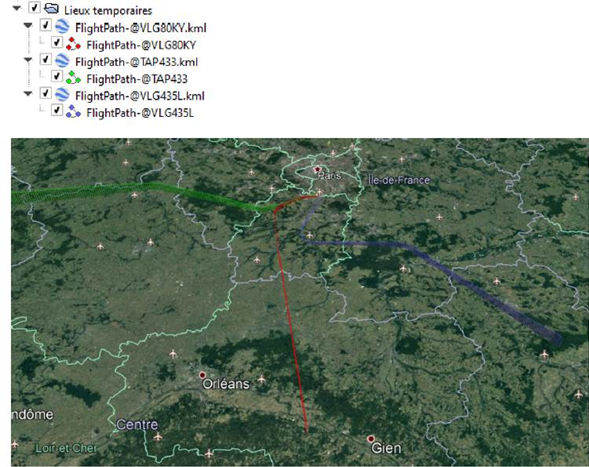
MW link v. Flight altitude analysis


Using HTZ, users can identify the potential impact of flight paths on MW links in and around an airport. Users must assess the viability of predefined microwave links and the potential intersections between the Fresnel zone for each beam and the flight paths.


Full article 

Coverage analysis with new + existing buildings
Product Feature

ICAO Building heights

This function computes the max. building heights on each point of the map, for seen and not seen points. This automatically checks the max clearance and then re-calculates a new dataset based on the ASCII-GRID format. Essential when modelling the impact of new buildings on Radars and other airport comms equipment.

Radar min. detection height showing radar coverage at different heights
Product Feature

Exclusion zones

This function supports coexistence modelling between 5G and radio altimeters by calculating the min. the separation between bands, taking into account the digital terrain model, buildings, flight path and flight height and the 5G network deployment. Once parameters are input, including propagation modelling, transmission power and antenna height, pattern and tilt, the uplink signal to the radio altimeter can be modelled.


Multilateration accuracy map (MLAT)
Product Feature

Multilateration

The MLAT function calculates the location of an aircraft accurately. TDOA calculates the time difference between the signals received by multiple sensors, while TSOA calculates the time synchronization of the signals received by multiple sensors. Both methods reduce errors in locating aircraft and enhance tracking accuracy.  HTZ uses advanced algorithms to calculate the location of the aircraft with the TDOA and TSOA methods to improve the accuracy of results.
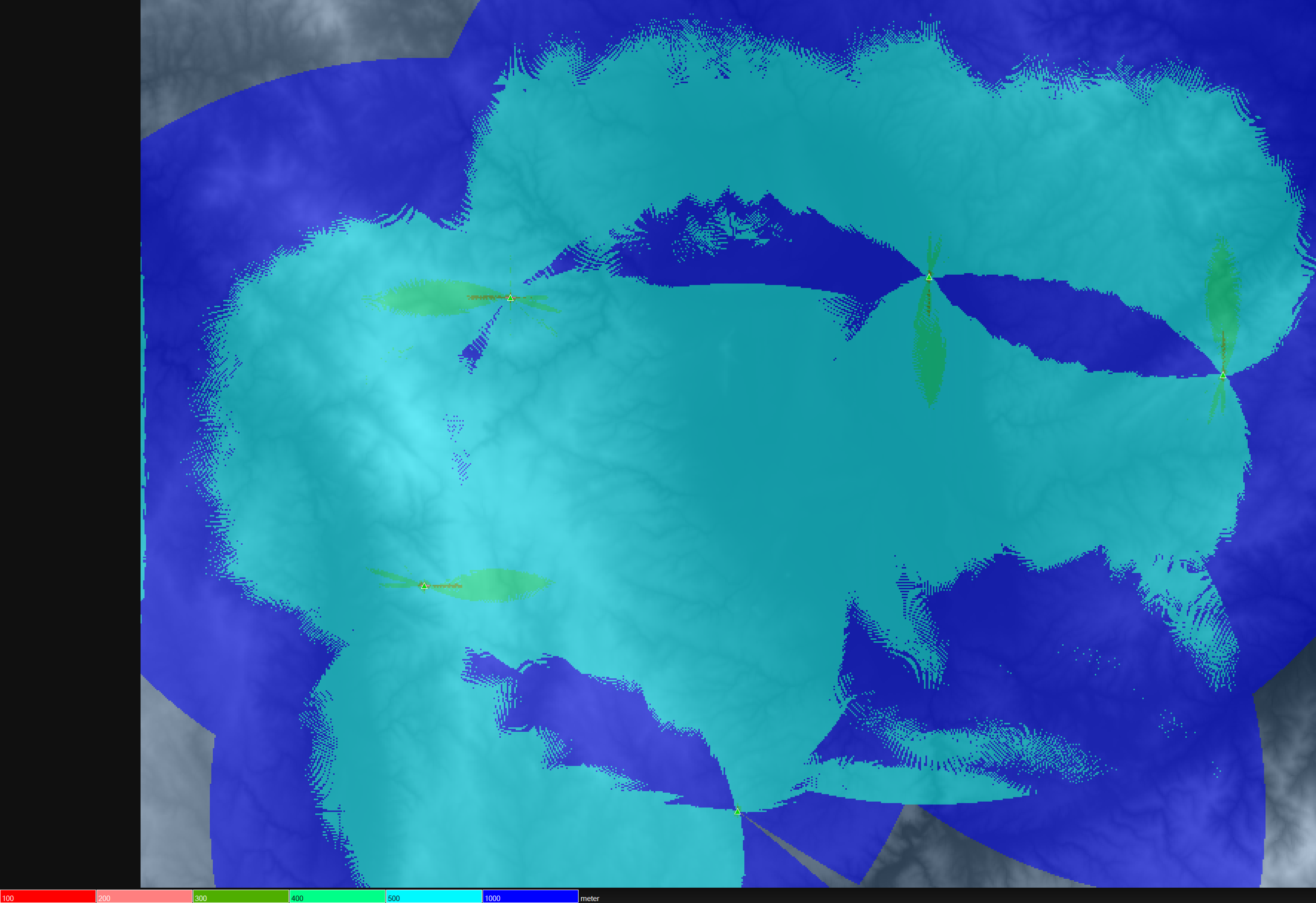
Localization of Direction Finders
Product Feature

Localization

The localization accuracy map featured in HTZ, allows the user to determine the localization accuracy of a network consisting of Direction Finders. These detect the best possible locations for virtual transmitters located on the map.

Drones & Anti-Drones

As the use of drones or unmanned aircraft (UAV) grows, businesses and Governments are seeing significant demand across areas like transport, military, logistics and commercial sectors. ATDI has implemented key features to support mission planning, jamming efficiency analysis, drone-controller localisation, radar detection capability analysis and flightpath RF simulation analysis. The reception analysis feature computes coverage in a 3D environment at different elevations. 

The presence of drones near airports can pose significant safety and operational risks, including the potential for collisions with manned aircraft, disruptions to flight schedules, and security concerns. Counter-drone, or counter-UAV (Unmanned Aerial Vehicle), technologies and strategies are designed to detect, track, and mitigate the threat posed by unauthorised or malicious drones. HTZ is used extensively to manage drones and anti-drones. It creates batch coverage maps at various altitudes across dense urban areas and identifies potential sites for not-spot coverage. 

To learn more about using UAVs as target decoys, counter-drones for combat missions and R&D, contact us today.


Indoor Modelling

Indoor coverage

HTZ  Communications can model communications inside terminals and hangers in the airport. The indoor modelling supports multiple technologies, including WiFi 6. HTZ features an ITU propagation model for indoor environments and allows the user to specify building materials in the settings.

View the HTZ tutorial here


Our Services

Our consulting services span the whole lifecycle of the network implementation from network planning to coexistence and interference analysis. Projects vary considerably and range from analysing the impact of 5G towers on airport navigation systems to modelling the effects of a new building on airport comms. Our technical team consists of subject experts who can model complex scenarios with ease. Talk to us today.

TECHNOLOGIES

KEY FEATURES

Our dedicated development team ensures that our software solutions continue to develop and evolve. Users can manage any radio technology across the spectrum to model multiple technologies across one project.

Technologies supported include 4G/5G, Microwave/P2P/P2MP, LoRaWAN, Wi-Fi, VHF/UHF/LF/MF and TETRA.

Navigation systems covered Radar, 
VOR/ILS/GS/GPS, Satellite, HAPSand MLAT.


- Analyses coverage across the airport for both indoor and outdoor communications.
- VHF G2G coverage simulations to identify black spots.
- Coexistence analysis to protect airport communications from terrestrial interference.
- Supports indoor network deployments for cellular, mobile and Wi-Fi 6 coverage. Building data can be manually extracted from digitised floor plans and imported for modelling (supported by AutoCAD).
- Supports ITU-R P.1147-4 and ITU-R P. 368-9 and -10 for managing skywave propagation at night.
- Models the impact of new buildings on airport communications, directly importing and creating new buildings from vector files to model its impact on signal attention.
- Models aircraft transmitters/receivers including DF/ADF, VOR, ILS, and GPS.
- Manages MW links including profile budget calcs, frequency and space diversity, link optimisation and P2P/P2MP link analysis (DL and UL).
- Models broadband LTE A2G systems including throughputs and aircraft altitudes. The outputs highlight RSRP coverage and best server RSRP maps, DL and SNIR maps.
- Supports standalone and non-standalone 5G deployments featuring network roll out, automatic cell planning and network optimisation. For the full list of features, see image below.
- Enables 4G/5G broadband coverage, interference (inc ATPC) and coexistence analysis for HAPS.
- Manages radio navigation systems including Doppler VOR, Instrument landing systems (ILS) and Coordination with FM systems.
- Supports SM1009 to check compatibility between sound broadcasting services in 87-108 MHz and aeronautical services in 108-137 MHz bands.
- Manages ILS/VOR coordination and FM coordination.
- Supports Radars and multilateration systems (MLAT) including surveillance radars (PSR/SSR) and the coexistence between radars and other systems.
- Features radar minimum detection height analysis for radar coverage, radar interference analysis calculating the I/N and threshold degradation and coexistence between radars and wind farms, see Wind farms under technologies.
- Supports multilateration which uses multiple ground-based sensors or receivers to triangulate the aircraft's location. HTZ identifies where to place the sensors and evaluates the accuracy and range of the sensors. HTZ can assess the accuracy of the MLAT in terms of TDOA and TSOA.
- Counter-drone network design to detect and locate unauthorised drones.
- Identifies and analyses the impact of harmful interference across a wealth of different systems and sources. See the documentation below for further information.
- Checks compliance with ICAO Building requirements within or around the airport for airport communication systems.
- Automates coverage planning to reduce network design and deployment processing times.